|
|
|
|
|
News
Order a Brochure
New Activity
Free Guided Walks in the Peak
District
Accommodation
New Attraction
Lea Nr Matlock Bath
Residential Art Courses in Painting, Sculpture and Drawing
New Website

|
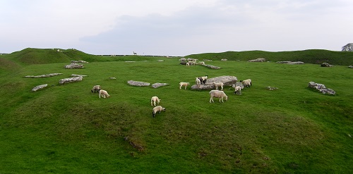
The Route - Kilometre 85 to 101Kilometre 85 (Mile 53) Parsley HayPark the car (30p) and go for a stroll. There is an easy walk mainly along the old railway track bed. This is a very easy walk due to its almost totally flat nature. Various cycles can be hired from here. In 2001 the Parsley Hay Cycle hire centre is open 7 days a week from March to November. In December, January and February it only opens at weekends. It opens at 9:30 with the last cycle hire at 4pm. The cost of a mountain bike is £3/hour or £10 for the day. You will need a £20 deposit PLUS proof of identity and address. Returning to the A515, turn left and then immediately right onto an unclassified road which is signposted to Monyash, Youlgreave and Arbor Low. Take the first right after 200 meters, again signposted to Arbor Low. 1.0 kilometres (0.6 miles) on the right is a farm track. Kilometre 87 (Mile 54) Arbor LowThis track leads to a small parking area for Arbor Low which is the largest
stone circle
Return back along the farm track to the unclassified road and turn right. Continue along this road for 3.1 kilometres (1.9 miles) where the road turns right (and is signposted to Youlgreave). In 400 metres (0.2 miles) turn left at the Give Way. In 1.4 kilometres, (0.9 miles) there is free parking on the left. This is the Coldwell End car park. Kilometre 92 (Mile 57) YoulgraveThis car park is several hundred metres before the centre of Youlgrave, but parking in the village is extremely limited. However, the car park is free and there are public conveniences here. It is highly recommended that this interesting village is explored on foot. But first, the observant may have noticed that the spelling of the village has changed. Although most road signs spell the village name as Youlgreave, the villagers spell it Youlgrave. The villages also call it pommy after the sound made by the drum that beats through the streets. Youlgrave is one of the larger villages in the Peak Nation Park and
has three long distance paths passing through it. They are the
For the casual walker, there is a leaflet, available from the Public Houses, that describes 5 walks around the village that vary in time from 30 to 45 minutes. While in Youlgrave you must visit the water fountain which is in the apt named Fountain Square that is just off the Main Street about 150 metres before the church. The water fountain is a large structure and is in fact a reservoir. During the night it would be recharged with fresh spring water. At 6am each day it would be unlocked. Forty year after it was first installed, ten more taps were installed throughout the village. To mark this event, the ancient ritual of well dressing was once more enacted but in a male dominated manner. The well dressings are done by the men whereas the women and children construct the garlands which, in earlier years, adorned the frames. But changes were afoot, and after the second world war, women were allowed to 'petal' the border, but not the main picture! Youlgrave's well dressing starts on the nearest Saturday to Saint John the Baptist's day (June 24th). See the comprehensive list of well dressings which includes other villages and towns within the Peak District National Park and many outside the Peak National Park.
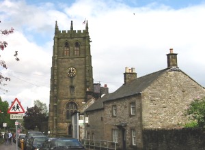
Whilst in Fountain Square look out for Thimble Hall. On the 9th August 2000 it was officially recognised as the world's smallest detached house! By Fountain Square is the Youth Hostel. Prior to being a Youth Hostel, this building was the Co-Op. It was a full department store and, before the recent modernisation, it was possible to for men to validly claim to have spent a night in 'Ladies Underwear'. We would recommend the George Hotel, opposite All Saint's Church, for a refreshment stop. In 2001 the menu was extremely varied and of a very high standard. The road to the centre of Youlgreave now becomes narrow, and it could take some time negotiating parked vehicles to reach the centre. In the centre of Youlgreave, follow the road to the left at the church with a tower and continue on for another 800 metres (0.5 miles) and stop in the village of Alport. Kilometre 93 (Mile 58) Alport and Lathkill DaleThere is a small rough unofficial car parking area on the left. At Over Haddon, about 3 kilometres (2 miles) up Lathkill Dale there is a nature trail. Over Haddon also has well dressings in July. See the comprehensive list of well dressings which includes other villages and towns within the Peak District National Park and many outside the Peak National Park. Leaving Alport, after 1.5 kilometres (0.9 miles), turn right onto the B5056 towards Ashbourne. This junction is just after a sharp left bend. After 0.5 kilometres (0.3 miles) turn left (up a very steep hill) and continue to Stanton in Peak. Drive through Stanton in Peak, following the road uphill and round to the right (Birchover Road) towards Birchover. 200 metres after this bend, there is a track off to the left, immediately followed by a little lay by for about 3 cars. Kilometre 96 (Mile 61) Stanton MoorThe are many standing stones and stone circles on nearby Stanton Moor.
This track by the lay by goes directly to the King's Stone (SK 245 634) from here, head north east to the Nine Ladies Stone Circle 40 metres away. The Nine Ladies Stone Circle consists of nine millstone grit stone - none of which are over 1 metre tall. Legend has it the nine ladies were turned to stone for dancing on the Sabeth and the King's Stone was the fiddler! However, the stone circle date from around 2000 B.C when many stone circles were being built in Britain and Europe.s From here, take the North West path (if you have a compass!). Continuing for 1.4 kilometres (0.9 miles) when the Ann Twyford Dimensional Stone Ltd shop is reached. The car park is on the right. In the car park there are some large blocks of pinkish stone. These have been quarried from nearby Stanton Moor and are a contrasting colour to the usual dark gritstone used for the dry stone walls. Continue down the steep hill and in 300 metres you are in the centre of Birchover. Kilometre 98 (Mile 61) BirchoverThere are public conveniences here. Birchover is a village of great antiquity and it is mentioned in the Domesday book. It is also near to some magnificent rock scenery and rock climbers are liable to be seen on the Rowtor Rocks. Continue for another 200 metres until The Druid Inn public house is reached. This is on the bend as the road turns to the right. To get to the Inn's car park, do not turn right, but go straight on, down the lane for 20 metres and the car park is on the left. The Druid Inn is an excellent place to stop for food and drink (and to admire the scenery). From the Druid's car park, drive back up the lane and turn left to go around the Inn and down the hill. In 1 kilometre (0.6 miles) turn left onto the B5056 signposted towards Ashbourne. In another 2 kilometres (1.2 miles) turn left onto the B5057 to Winster. Next Section |
Popular Derbyshire Guide Pages
JavaScript is required view this information and it would appear that your browser does not have JavaScript or JavaScript has been disabled.
Legal
This information is provided to the best of our knowledge.
We have collected and collated it in good faith but we are not responsible for its accuracy
and anyone intending to make use of this information is advised to check it out.
Well that's the legal stuff sorted. Should you decline to comply with this warning, a leather winged demon of the night will soar from the deep malevolent caverns of the white peak into the shadowy moonlit sky and, with a thirst for blood on its salivating fangs, search the very threads of time for the throbbing of your heartbeat. Just thought you'd want to know that. |
||
 Peak District and is surrounded
by an unusually large ditch. It dates from the late
Peak District and is surrounded
by an unusually large ditch. It dates from the late
 Some of the cottages are
built of the local pinkish stone from the nearby Stanton Moor quarries.
These cottages have a warmer appearance than the usual building material
of the area, grey gritstone.
Some of the cottages are
built of the local pinkish stone from the nearby Stanton Moor quarries.
These cottages have a warmer appearance than the usual building material
of the area, grey gritstone.