|
|
|
|
|
News
Order a Brochure
New Activity
Free Guided Walks in the Peak
District
Accommodation
New Attraction
Lea Nr Matlock Bath
Residential Art Courses in Painting, Sculpture and Drawing
New Website

|
IntroductionGeneralWithin today's hectic lifestyle, it is increasingly difficult to spend as much time as one would like to become acquainted with areas of beauty. This guide is written especially for those who have limited time to spend exploring the Peak District. It describes a motoring route through the Peak District highlighting points of interest. The route passes many aspects that have made the Peak District a popular place. Much of the route lays within the boundary of the Peak National Park. All the major show caves are on the route. The natural scenery is immensely varied, from vertically sided gorges to flat high plateaus. Man-made attractions are even more diverse ranging from International Opera Festivals to local Well Dressing; Olde Worlde Trams, Trains and Traction engines to modern microscope viewers; Stone Circles to dry stone walls. Many writers have found inspiration here. Hathersage is believed to be Morton in Charlotte Brontë's Jane Eyre, Jane Austen's novel Pride and Prejudice was written while she stayed in Bakewell, and the author of The Compleat Angler, Izaak Walton, used to fish in Dovedale. Nobility is present in the area, with the ancestral homes of both the Duke of Devonshire and the Duke of Rutland being on the route. Despite being called The Peak District, there are no peaks in the normal sense of the word. The word peak which describes this area, derives from the Saxon peac that means a hill. Indeed, the hills of Derbyshire are very popular and they make this an extremely pleasant walking county. This guide is not confined to any particular aspect of the area, but attempts to give a balanced view of the many different facets of the Peak District. It concentrates on what can be seen and what activities are possible at the present time. There are many other good books that can be consulted for a comprehensive historical viewpoint of this area. Where appropriate, historical facts and personalities will be mentioned. With a total distance of about 200 kilometres (125 miles), the route is a figure of 8. Both loops are approximately the same length and are centred on the Bakewell to Matlock road. The Peak National Park attracts nearly 30 million visitors a year, only Mount Fuji National Park in Japan has more visits!. Obviously, some spots are more popular than others. This can cause traffic problems on roads serving these areas, especially at the busier times, such as bank holiday weekends. Most of the route will travel away from the major trouble spots but if delays are encountered, the time can be usefully spent admiring the beautiful scenery that abounds the area. Although the route description starts and finishes at Bakewell, there is no reason why an alternate start point cannot be used. This makes it an extremely flexible guide and, being constructed of paper, is more flexible than the stone tablets God handed down to Moses!
OrganisationThe guide is split into three parts.
What is a National Park?Well, that is a tough question. It is actually far easier to say what a National Park is not. It is neither owned by the National Government nor is it a Public park. There is no universal right of way in the park. This is not quite what William Wordsworth had in mind when, in 1810, he wrote about the Lake District (the second national park to be created) saying "A sort of national property, in which every man has a right and an interest who has an eye to perceive and a heart to enjoy." Wordsworth did not live to see his vision come to fruition. Although the Peak National Park was the first and one of the largest of the 12 British National parks, it was not created until 1951 when it was known as the Peak District National Park. This is 101 years after Wordsworth's death and a trifle later than the United States which created the world's first national park, Yellowstone, way back in 1872. The park encloses 1438 square kilometres (555 square miles). The land in the park belongs to a variety of people and organisations. Some is owned by individuals such as farmers, land owners, and home owners. Large tracts of land are owned by the National Trust, an independent, non government organisation, which allows the public free unfettered access to most of its land. The only rights of way for the public are marked on the Ordnance Survey maps, and even these can change from time to time. Thus, the byword must be 'tread carefully', not only to protect the wild plants and flowers, but also to reduce the likelihood of trespassing. A public right of way (PROW) is usually a track or path that the public has the right to travel over. It is a detailed subject on what rights the public has, and the Open Spaces Society has written a very good article about the right to picnic on a PROW. It is easy to spot the limits of this national park as most of the major roads have a splendid park boundary marker; it is an old grindstone made from locally quarried Millstone Grit. English Heritage National Trust The National Trust owns about 12% of the land within the Peak National Park. Many road signs to National Trust properties use the icon on the left. Some of its properties are very popular. Dovedale has between 2 and 3 million visitors each year. At its peak there are about 3,000 visitors arriving each hour. MapsThe whole route can be followed on the Ordnance Survey Landranger 1:50 000 series map numbers 119 and 110. The Ordnance Survey Tourist map number 4 Peak District can be satisfactorily used even though it neither covers about 11 kilometres (6 miles) around the Ashbourne area nor 400 metres at Crich. If a good deal of time is to be spent walking in the area, there are many Ordnance Survey Landranger 1:25 000 series maps available. The 1:50 000 maps are about 1¼ inches to the mile; The 1:25 000 maps are about 2½ inches to the mile; and the Tourist map is exactly 1 inch to the mile. Often, a Grid Reference will be given to specific sites of interest. The reference system is the National Grid Reference and a brief description on how to find a place using a grid reference is given on the Ordnance Survey Maps. GeologyRocks are hard, especially the Carboniferous limestone which is the predominant rock found on this tour. Geological time is mind bogglingly long. The earth was formed about 4,600 million years ago. Geological time is divided into periods. Some more recent ones are
The Peak District limestone was created about 350 million years ago during the Carboniferous period when Britain was moving north across the equator. What is now limestone scenery was, in Carboniferous times, tropical coral reefs in shallow water. At that time there were neither flowering plants nor grasses. A very different site than today. There were some active volcanoes in the area at this time. Volcanic activity usually results in mineral veins being created. In Derbyshire the major deposit was lead. It was also the time when the coal fields of neighbouring Nottinghamshire and Yorkshire were being formed from the decomposing remains of giant tree ferns and conifers. The Carboniferous period was the age of amphibians. Reptiles appeared later in the Permian period, and dinosaurs appeared even later. The Dinosaurs first appeared about 215 million years age during the Triassic period. They dominated the whole earth during the Jurassic and Cretaceous periods but, suddenly, ceased to exist after the Cretaceous period. So, for the last 65 million years, the planet has been devoid of dinosaurs. And man? Well, he's the 'new kid on the block', appearing on the scene about 2.1 million years ago as Homo Habilis. Homo Erectus appeared 1.5 million years ago. Modern man, Homo Sapiens has only been around for 80,000 years and is responsible for most of the scenery in the Peak District. He is the one who cut down the forests and built the dry stone walls. Lead MiningThe Peak District is littered with many old and abandoned lead mines. Lead ore is dug out of the ground, then smelted so that the lead mineral can be separated from the rock. The molten lead is then poured into a mould and the solid lead bar is called a pig. The Romans were the first to exploit lead in this area. They were so successful, and Derbyshire so prolific, that a quarter of all Roman lead pigs found in Britain can be traced back as originating in Derbyshire. These pigs have been found as far away as Humberside to the North East and Sussex to the South. Thus, Derbyshire was a very important area for the Romans. Derbyshire maintained its lead mining prominence for over one thousand five hundred years. In the Domesday book, which was written in 1086, Derbyshire was cited as the only county which had a lead industry. Its heyday was probably 1861 when 2,333 (10% of the population) were directly employed in lead mining activities. However, in the twenty years to 1881 the number of workers had dramatically reduced by two thirds to 871. This was due to Australian lead ore, which was easily mined and therefore much cheaper. The industry never recovered from the Australian competition, and nowadays the lead industry deals with lead processing and not the extracting of lead from out of the ground. Well DressingDerbyshire, which is the major county in the Peak District is world famous for its well dressing. They can be seen from May to September throughout the county. Probably the most well known village that has well dressing is Tissington which is the first village to hold their well dressing festival in May. Making a Well Dressing
Most well dressings are of a similar form.
Near the well will be a large
wooden frame containing a picture made out natural materials. Rain is not the biggest threat to the pictures. Most rain will run off of the pictures, but wind will cause the clay to dry out, then it will crack and the petals may be blown away. The best time to see the dressed wells is in the first three or four days after they have been erected. The index lists villages on the route that have well dressings. See also a comprehensive list of well dressings which includes well dressing within the Peak District National Park and many villages and towns outside the Peak National Park which have well dressings. The Origin of Well DressingThere is no definitive explanation as to why they were started. It is thought that they originated in pagan rituals or sacrifices to water gods as a thanks for past supplies and a request for continuing future deliveries. With much of the Peak District residing on porous limestone, water could, at times, be in short supply. The scarifies are thought to have been replaced by the colourful decoration as a tribute to the gods. It is known that the Romans made similar offering to their gods and one theory says that they probably brought this custom to Derbyshire. Unfortunately, no similar custom exists in modern Italy. So, the most favoured theory has the custom originating before the Romans and that is was a Celtic custom that managed to survive the successive invasions of Romans, Saxons, Danes, and Normans. What is more certain is that the early Christian Church absorbed the pagan rite into it. The early Christian Church has an history of absorbing rather than suppressing pagan customs. Why else is Christmas day so close to the shortest day? In pagan times this was a time of rejoicing as the days would now get longer. And why is Easter a moveable feast? The name Easter comes from Eastre, an ancient Anglo-Saxon goddess, originally of the dawn. In pagan times an annual spring festival was held in her honour. Some Easter customs have come from this and other pre-Christian spring festivals. Thus, most modern day well dressing coincides with religious festivals with the pictures depicting a biblical or moral theme. Indeed, one primary school has used the paintings of L.S Lowry, who lived that later part of his life in Derbyshire, for its well dressing. As part of the absorbing of the well dressing tradition, it is thought the the Christian Church gradually changes the well dressing themes to a religious theme and allowed the well dressings to be more complicated with the modern day picture frames. Although many of the wells are not in active use, the tradition of well dressing survives to this day. Yards, Metres, Miles and Kilo-whotsitsThe guide principally uses the metric system. Back in the swinging 60s Britain had a Metrication Board to wean us from the Imperial way of thinking to the Metric system. So, we now have 100 pence to the pound (rather than the more discriminating 240), 1000 metres to the kilometre (rather than the more athletic 1760 yards to the mile), 10 decilitres to the litre (rather than the more drinkable 20 fluid ounces to the pint and 8 pints to the gallon), and the Hectare rather than the beautifully defined acre (which is one furlong long and a chain wide). Have you ever wondered what a furlong and a chain are? Well, a chain (or to give it its Sunday name, Gunter's Agricultural Chain) is 22 yards and is the distance between the stumps on a cricket field. A furlong derives from the words 'Furrow long', and was the length of a furrow in the common field (220 yards or 10 chains). An acre was the amount of land that a yoke of oxen could plough in a day. For those not totally familiar with the metric system, the following notes may help:
It is surprising that the EEC bureaucrats (those great harmonisers!) have not yet forced us to change. Thus, signposts measure miles, and garages sell petrol in litres. At least we have not adopted the Irish situation where speed is measured in miles per hour and distance in kilometres. Tweedle Dum and Tweedle Dee would have a great time in this land. See our kilometres into miles (and vice versa) converter. IconsThroughout the guide, icons are used as an easy reference to important items. The most frequently used icons are those that indicate if it is necessary to vacate the car to see or experience a particular thing.
PricesWhere possible, prices have been included in the guide. Inflation has been a way of life in Britain for many decades and even though it has now reduced it is likely that admission costs will be higher than those given in this book. To gauge the amount of the increase an International Financial Index will be used. Some International Financial Organisations use the time spent working to earn enough to purchase a Big Mac™ as a sign of the financial state of a country. Who am I to argue with financial experts? At the time of writing the cost of a McDonald's Big Mac™ was £1.66, and the cost of a loaf of bread from a supermarket was 55p. However, if you are on a limited budget, or do not like paying more than necessary, look carefully in the Tourist Information Centres. Not only will they have the current admission prices but quite often there will be discount vouchers on their leaflets. Why attractions do not permanently reduce their prices is a mystery to me. After all, as the saying goes, 'there is no such thing as a FREE lunch'. SecurityUnfortunately, the Peak District is not immune from thieves. Every year a few cars are broken into and the valuables removed. This is not a high risk area, but one theft is one too many. Thieves operate all over the country and while it is not possible to stop them a few precautions will reduce their negative impact on your enjoyment. So, try to observe the following advice:
These measures will not stop the thieves breaking into the vehicle, but it will reduce the amount of anguish and later the hassle of claiming on the insurance and replacing the stolen articles. Having said all this, I have had my car broken into three times and in all cases they were not in the Peak District. In all cases it was in areas that I frequented a lot less than the Peak District. One was in rural Lincolnshire, another was a small seaside town in Kent and the last was in a station car park in south east London. DirectionsWhile descriptions of the landscape are in a normal text, directions are highlighted by rendering the text so. In the description of the route, the phrase 'towards A' is used to indicate that either a turn off of the road before 'A' is reached, or that there is something to see or do before 'A' is reached. So, are you sitting comfortably, seat belts fastened, engine on, check the mirror, and away we go....... |
Popular Derbyshire Guide Pages
JavaScript is required view this information and it would appear that your browser does not have JavaScript or JavaScript has been disabled.
Legal
This information is provided to the best of our knowledge.
We have collected and collated it in good faith but we are not responsible for its accuracy
and anyone intending to make use of this information is advised to check it out.
Well that's the legal stuff sorted. Should you decline to comply with this warning, a leather winged demon of the night will soar from the deep malevolent caverns of the white peak into the shadowy moonlit sky and, with a thirst for blood on its salivating fangs, search the very threads of time for the throbbing of your heartbeat. Just thought you'd want to know that. |
|||||||||||||||||
 This is an organisation with was created by Parliament
in 1984. It exists "to protect and enhance those historic buildings
and sites which make up the fabric of the nation; the great inheritance
which symbolises and enriches our national life."
This is an organisation with was created by Parliament
in 1984. It exists "to protect and enhance those historic buildings
and sites which make up the fabric of the nation; the great inheritance
which symbolises and enriches our national life."  The National Trust was founded in 1895 and is a
registered charity, not a government agency. It relies on the voluntary
support of its 2-3 million members and the general public. It is also
the largest private landowner in Britain with over 570,000 acres (which
is approximately 380,000 football pitches).
The National Trust was founded in 1895 and is a
registered charity, not a government agency. It relies on the voluntary
support of its 2-3 million members and the general public. It is also
the largest private landowner in Britain with over 570,000 acres (which
is approximately 380,000 football pitches). 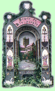 The predominant material is petal leaves.
The technicalities
of the construction is that the wooden frame is full of nails, a little
like a bed of nails.
Into this frame is spread clay, about 25mm (1") thick.
This will have been collected seven to ten days before the festival.
During
the intervening period it is 'puddled' - a process whereby the well dressers
walk over the clay in much the same way as grapes used to be pressed.
This has the effect of softening the clay and makes the removal of stones,
grit, twigs, and other unwanted contaminates easier.
A little salt is
added to the clay to assist with its water retention.
Then the image is
marked out with seeds, small stones, or coffee beans, in much the same
way a child's colouring book looks.
Then the coloured images are filled
in with petals, Hydrangea are good for blue skies, moss for greens and
bark for trees and buildings.
No self respecting well dresser uses any
paint whatsoever.
They will use diverse natural materials such as
eggshell, lichen, straw, wool, stone or coal to give their well dressing the colours it requires.
It will take a proficient well dresser about seven hours
to attach all the petals.
They are laid like tiles so that any rain will
run over the petals and off the bottom of the picture.
The predominant material is petal leaves.
The technicalities
of the construction is that the wooden frame is full of nails, a little
like a bed of nails.
Into this frame is spread clay, about 25mm (1") thick.
This will have been collected seven to ten days before the festival.
During
the intervening period it is 'puddled' - a process whereby the well dressers
walk over the clay in much the same way as grapes used to be pressed.
This has the effect of softening the clay and makes the removal of stones,
grit, twigs, and other unwanted contaminates easier.
A little salt is
added to the clay to assist with its water retention.
Then the image is
marked out with seeds, small stones, or coffee beans, in much the same
way a child's colouring book looks.
Then the coloured images are filled
in with petals, Hydrangea are good for blue skies, moss for greens and
bark for trees and buildings.
No self respecting well dresser uses any
paint whatsoever.
They will use diverse natural materials such as
eggshell, lichen, straw, wool, stone or coal to give their well dressing the colours it requires.
It will take a proficient well dresser about seven hours
to attach all the petals.
They are laid like tiles so that any rain will
run over the petals and off the bottom of the picture.