|
|
|
|
|
News
Order a Brochure
New Activity
Free Guided Walks in the Peak
District
Accommodation
New Attraction
Lea Nr Matlock Bath
Residential Art Courses in Painting, Sculpture and Drawing
New Website

|
The Route - Kilometre 121 to 139Kilometre 121 (Mile 75) BaslowBaslow is entered after crossing a large bridge. Immediately after the bridge is a large roundabout. Turn right at this roundabout towards Chesterfield (A619) and Sheffield (A621). After about 500 metres (0.3 miles), after the Cavendish Hotel on the right and before the pelican crossing, there is a public car park on the right WHICH IS NOT SIGNPOSTED, or if it is refreshments time, continue for another 200 metres and pull into the Wheatsheaf Hotel's car park on the left. The public car park costs are 20p for up to 1 hour, 80p for 1 to 3 hours and £2 for over 3 hours. It has public conveniences. On the other hand, the Wheatsheaf Hotel serves good food and beer, and is very popular. It also has a beer garden with a good children's play area.
Return back to the car, and turn left out of the public car park onto the A619 and return to the large roundabout. At the roundabout continue straight on along the A623 towards Stockport and Manchester.
1.3 kilometres (0.8 miles) from the roundabout the River
Derwent can be seen on the left. 700 metres (0.4 miles) further, where the road crosses a river, there are craft shops, and tea rooms on the right. Nearby is a mill which was used as Colditz castle in the television series Colditz. In another 0.7 kilometres (0.5 miles), turn right at the Calver traffic lights signposted towards Hathersage and Sheffield. In 300 metres turn right onto the B6054 towards Sheffield via Froggatt Edge. In a few hundred metres there are very good views of Curbar and Froggatt Edges directly ahead and to the right. In a further 1.2 kilometres (0.7 miles) the Chequers Inn and Restaurant appears on the right. Kilometre 126 (Mile 78) Chequers InnThe Chequers Inn, built in 1575 serves lunch and dinner in the oak beamed bar seven days a week. The restaurant is open Tuesday to Saturday evening and Sunday Lunch. It is the perfect place to stop for good beer and excellent bar food. Indeed, after a few beers and an evening meal, it is a very pleasant place to spend the night.
The road slowly climbs to the top of Froggatt Edge. 2.2 kilometres (1.6 miles) from the Chequers Inn there is car parking down what appears to be a farm track on the left for the Haywood National Trust woodland. It is not signposted. Kilometre 129 (Mile 80) HaywoodHaywood is 76 acres of National Trust woodland. It has a car park and several good walks start from here. There is a finger post in the car park which shows the walking routes. These walks are along well marked paths and vary from the fairly gentle to Froggatt Edge to the very strenuous to Nether Padley (its easy going down but nowhere near as easy coming back up!). Return back to the road and turn left.
200 metres on the left is a parking bay on the left side of the road.
At this point the scenery has suddenly changed from being the meadow type land of the valleys into the bleakness of the high moors with its angular tops. A further 300 metres and we pass one of several entrances to the National Trust 650 hectare (1600 acre) property of the Longshaw Estate. All car parks for the Longshaw Estate have a charge for non-National Trust members. There are no entry chages for access to the Longshaw Estate. From the road, the better views are on the left.
In a further 1.1 kilometres (0.7 miles) there is a National Trust car park on the left. There is an information centre near here. From this site there is fairly flat walking and some views of the edges. 300 metres further on, turn left onto the B6055 towards Sheffield. Thus is a triangular junction.
In 400 metres keep left on the B6055 towards Hathersage and Castleton. In 500 metres, on the left, is a National Trust car park. This is the main car park for the Longshaw Estate. Kilometre 131 (Mile 81) Longshaw Estate
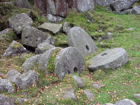
In the satelite image below the mill stones can just be made out in the quarry.
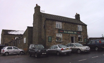
In 2011 the Longshaw Estate was loaning free GPS receivers for Geocaching. Geocaching is an outdoor sporting activity in which the participants use a Global Positioning System (GPS) receiver or mobile device and other navigational techniques to hide and seek containers, called "geocaches" or "caches", anywhere in the world. A typical cache is a small waterproof container containing a logbook where the geocacher enters the date they found it and signs it with their established code name. Larger containers such as plastic storage containers (tupperware or similar) or ammunition boxes can also contain items for trading, usually toys or trinkets of little value. Geocaching is often described as a "game of high-tech hide and seek", sharing many aspects with benchmarking, trigpointing, orienteering, treasure-hunting, letterboxing, and waymarking. The Longshaw Estate has, in 2011, five caches. To find all five requires a walk of around 3 miles and it took the Derbyshire Guide Team around 3 hours to stroll around the route. Kilometre 132 (Mile 82) Fox HouseWhen the Fox House Inn is reached in 800 metres (0.5 miles), keeping Fox House on the right, go onto the A625 signposted towards Castleton, Hathersage, and Hope. Alternatively, pause for a while in the car park and public conveniences to the right of the Fox House public house. There is a theory about public houses in the middle of nowhere; they must be good to survive. Is this a good time to test the theory? 700 metres after leaving Fox House, the road makes a 90 degree left turn.
In 1 kilometres (0.6 miles) there is car parking on the right which is a good base for walking around this area. 400 metres further and the brink of Millstone Edge is reached and the road does a sharp right hand bend. Kilometre 134 (Mile 83) The Surprise
The road now winds its way gently down 130 metre (400 feet) into Hathersage. Kilometre 137 (Mile 85) Hathersage1.1 kilometre (0.7 miles) after the "Welcome to Hathersage" sign, with the Millstone Inn on the right, the spire of the village church can be seen on the hill side. This is where Little John (of Robin Hood fame) is buried. In the centre of Hathersage, there is the National Westminster Bank on the right. A little after this bank is the Royal Bank of Scotland and The George Hotel, again on the right. Turn left immediately after these onto the B6001 towards Bakewell and a car park. 300 metres along the B6001 turn left signposted to a car park and swimming pool; the car park is about 100 metres on the left. Parking charges are 20p for up to 1 hour, 80p 1-3 hours, £2 over 3 hours. There are no public conveniences in the car park, but there is a sign for "toilets via footpath".
The grave lies between two yew trees and is opposite the main porch of the church. The church has several books on Little John and Robin Hood. It is also a popular venue for Brass Rubbing. Hathersage has its own Well Dressing for two wells from the first Saturday in July. See the comprehensive list of well dressings which includes other villages and towns within the Peak District National Park and many outside the Peak National Park. For forthcoming and past events in Hathersage see Hathersage Events. Leave the car park and turn right. Back at the B6001 turn right. At the A625 turn left, towards Chapel-en-le-Frith.
Next Section |
Popular Derbyshire Guide Pages
JavaScript is required view this information and it would appear that your browser does not have JavaScript or JavaScript has been disabled.
Legal
This information is provided to the best of our knowledge.
We have collected and collated it in good faith but we are not responsible for its accuracy
and anyone intending to make use of this information is advised to check it out.
Well that's the legal stuff sorted. Should you decline to comply with this warning, a leather winged demon of the night will soar from the deep malevolent caverns of the white peak into the shadowy moonlit sky and, with a thirst for blood on its salivating fangs, search the very threads of time for the throbbing of your heartbeat. Just thought you'd want to know that. |
||
 It is worth exploring
  500 metres further on,
Baslow Edge is clearly visible on the right. This is a
gritstone outcrop and is typical of the new type of scenery
on this part of the route.
500 metres further on,
Baslow Edge is clearly visible on the right. This is a
gritstone outcrop and is typical of the new type of scenery
on this part of the route.
 This is followed by the
 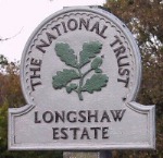 There is a charge for non-National Trust members for use of the pay and display car park.
There are no entry chages for access to the Longshaw Estate.
From the car park it is a gentle 300 metre stroll to the National Trust's Longshaw Estate Visitor Centre and tea room.
There is a charge for non-National Trust members for use of the pay and display car park.
There are no entry chages for access to the Longshaw Estate.
From the car park it is a gentle 300 metre stroll to the National Trust's Longshaw Estate Visitor Centre and tea room.
 The Longshaw Estate is gently rolling and many of the paths are accessible to wheelchairs and prams.
This is the best place to see mill stones.
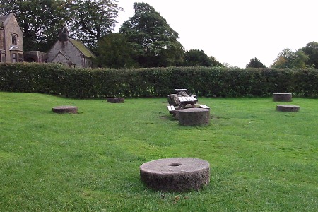
By the National Trust Tea Shop there is a picnic area that contains many mill stones.
The Longshaw Estate is gently rolling and many of the paths are accessible to wheelchairs and prams.
This is the best place to see mill stones.
By the National Trust Tea Shop there is a picnic area that contains many mill stones.